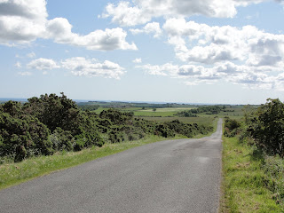
We took a couple of wrong turns when heading out to join the cycleway, which gave us our first taste of how relentlessly hilly the landscape is here - struggling over hilly roads to find you've come the wrong way only meant more hilly roads on the way back! The hills didn't stop; up and down and up and down and up and down. They weren't sharp, steep hills as they are in Yorkshire, but rather long, slow, painful hills, without much of a euphoric race downhill once you tip over the brow!
 |
| Cheviot Hills Elevation Map |
 |
| Compared even with our tougest ride, it was much hiller as you can see! |
Still, the scenery was incredible - it would have been easy to believe that we were in Scotland already! The landscape was harsh and remote, and it's easy to believe that you could hide in this part of the country for days without risk of being found (just as Raoul Moat did last summer).
The great thing was that we didn't feel like giving up the whole time. We were tired and sore, we were looking forward to getting home and having a shower, but we both felt like we could do it. No one got off and cried because they just couldn't face another hill! This is good news - this tells us what we need to know: we might actually have a chance at completing the 100 miles after all.
 |
| See that small splodge heading up the hill? That's me! |


No comments:
Post a Comment